Water and Play
Gothenburg’s Urban Challenge
“Gothenburg will be the best city in the world when it rains!“
www.goteborg2021.com
This is one of the goals formulated by the City of Gothenburg as it approaches its 400-year anniversary in 2021. Founded in the beginning of the 17th century, water has always played a predominant role in the city. On average, is rains every third day in Gothenburg, which is why the city has initiated its anniversary project “Rain Gothenburg” to bring its inhabitants closer to water, turning rain into a resource for public enjoyment. This is a creative approach to implement resilient and attractive solutions for water treatment to be used to change the negative perception of rain, using rain as an asset for environmental and social sustainability (göteborg2021.se). Projects like “Regnlekplats” (engl. rain playground) in Renströmparken and “Näsan i Blöt” (engl. the nose in wetness) in Jubileumsparken, are two existing examples of playgrounds that incorporate rain and water as playful elements. Additionally, the International Water Association (IWA) and the City of Gothenburg are collaborating on an effort to turn Gothenburg into a “water-wise city” by focusing on water sensitive design solutions (WSDS).
“Climate consideration and a sustainable lifestyle will become clearly defined elements in the day-to-day lives of the next generation of Gothenburg inhabitants. It is vital that children and young people acquire knowledge at an early stage about human impact on climate and how they can live in a good, climate-smart way.”
The City of Gothenburg
Extracted from: Climate Programme for Gothenburg (2014, p. 34)
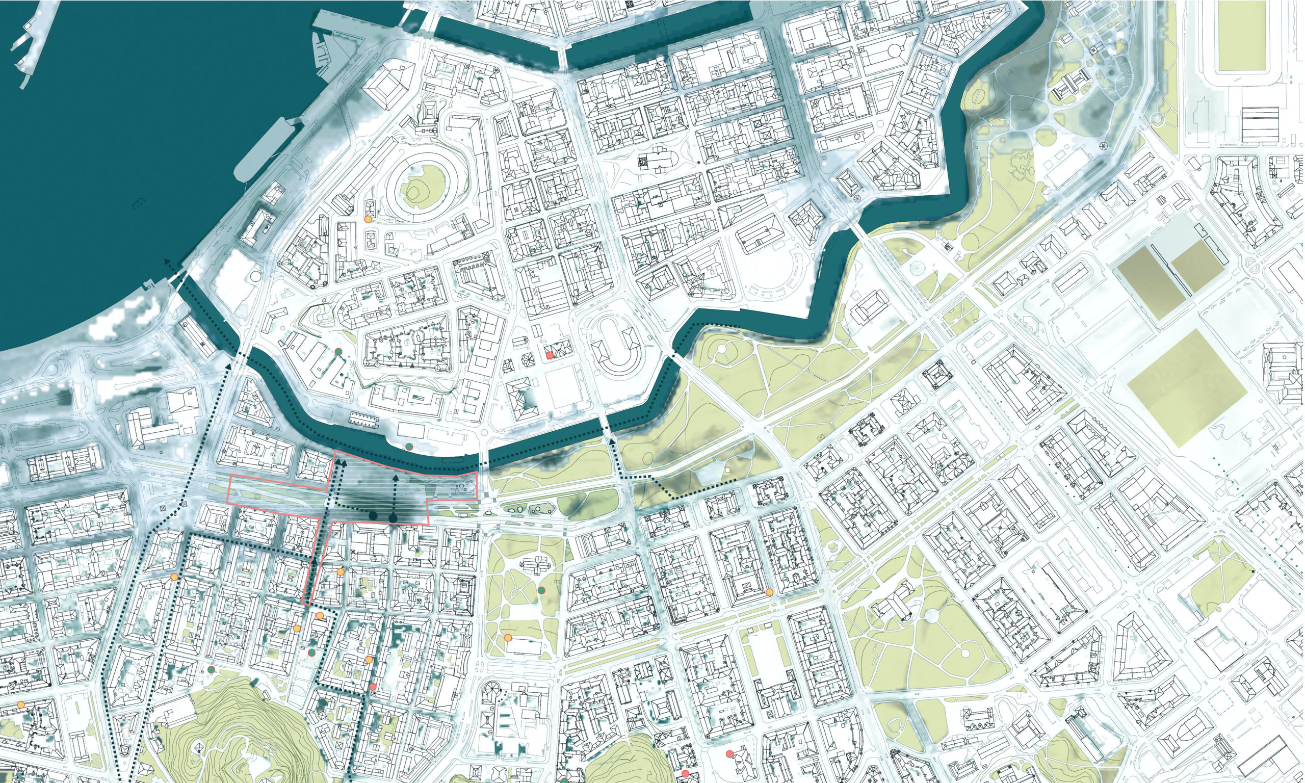

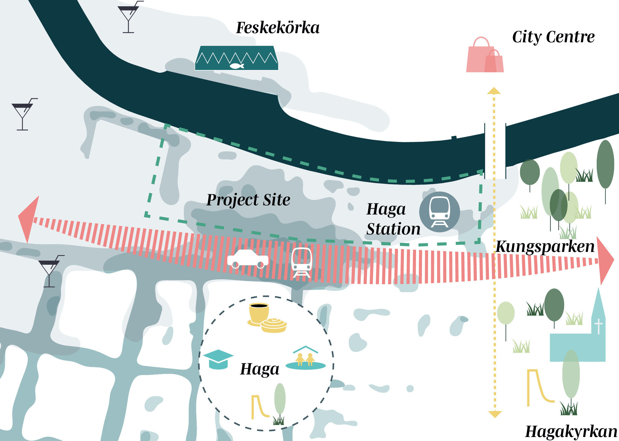
The Project Site: Pusterviksplatsen
Situated along the city’s historic Dutch channels, Pusterviksplatsen marks the end of Gothenburg’s central green structure, known as Kungsparken. Located in proximity to the old town (Haga), Hagakyrkan (Haga Church), Järntorget, the Linné area, the adjacent Kungsparken and Feskekörkan (the fish church) on the opposite side of the channel, the chosen area is at the core of Gothenburg’s historical heart. Although the square is currently neglected and functions almost exclusively as a parking lot, it is situated in one of the city’s most central and attractive areas.
Pusterviksplatsen is facing profound changes due to Gothenburg’s major ongoing infrastructure project “Västlänken,” which is the new construction of an underground railway extension below the historic city centre. At the time of writing this Master’s Thesis, Pusterviksplatsen is under construction, with portions of it designated to accommodate the new underground “Haga station”. At this moment, no further plans have been published by the City of Gothenburg regarding the remaining portions of Pusterviksplatsen.
The new station will have a long-lasting impact on the entire area. In line with this Master’s Thesis proposal, the child’s perspective will be taken into consideration. Through collaboration with Norconsult AB, Gothenburg’s building authority (Stadsbyggnadskontoret) has conducted an impact analysis of the children (Barnkonsekvensanalys) in regard to the Västlänken project and new Haga Station. The purpose of the study is to ensure that the design of Västlänken promotes a socially sustainable environment for the local inhabitants.
Water in the form of rising sea levels and heavy precipitation will become a problem for the site. On behalf of Göteborgs Krettslopp och Vatten (the local authority for water treatment) and Stadsbyggnadkontoret (the local building authority), Sweco has conducted a cloudburst modelling (Skyfallsmodellering) to two-dimensionally illustrate the accumulation of water and run-off routes within Gothenburg in the case of a 100-year-event and a 500-year-event. In both scenarios, the results for Pusterviksplatsen show that stormwater will flow towards Rosenkanalen, accumulating at depths up to 0,5 meters partially on-site, on the adjacent Nya Allén, and in the streets of Haga due to the topography of the nearby Linné area (see figure 42 and 43 in the appendix p. 96 and 97). This will disturb the area’s access and infrastructure, and, in worst-case scenarios, could pose risks to human health and life (Persson, J., Karlsson, A., Jansson, K. & Gustavsson, 2015).